
Planet Labs PBC (NYSE: PL), a leading provider of daily data and insights about Earth, today announced that it has expanded contracts with existing customers across the Canadian provincial governments, including British Columbia, the Northwest Territories, Quebec, and Alberta. Planet data and solutions will be used to support critical disaster response efforts during the Canadian fire season, and to monitor impacts of climate change on ecosystems, such as permafrost melt.
This press release features multimedia. View the full release here: https://www.businesswire.com/news/home/20231004651845/en/
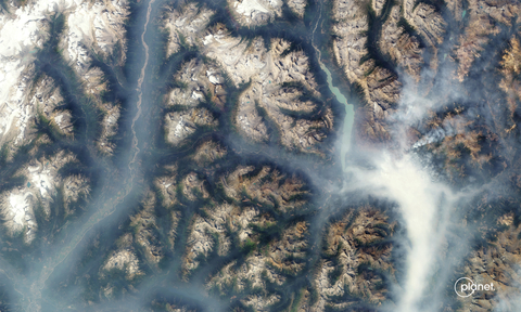
PlanetScope image of wildfire smoke in Revelstoke British Columbia taken August 21, 2023. (Photo: Business Wire)
Quebec and the Northwest Territories are expanding their work with Planet as a result of ongoing wildfires and their impact on Canada’s public health and safety and natural resources. With Planet’s unique PlanetScope data, these provincial governments are monitoring wildfires activity in near-real time, allowing them to spot and track wildfires as soon as they begin and to monitor their rapidly changing pathways. Using Planet SkySat tasking satellites, the governments are gaining situational awareness with high-resolution imagery of the fires, enabling a rapid characterization of their severity and impact on the environment.
Additionally, the Alberta government recently used Planet Basemaps to help coordinate response ground crews and assess fuel loads this summer in relation to the ongoing wildfires and prevention efforts. According to reports, as of August 22, there were 1,000’s of fires actively burning across Canada, marking this as the country’s worst wildfire season on record.
The Province of British Columbia has licensed Planet mosaics for internal use by all provincial ministries. This service provides high resolution cloud-free color satellite imagery for the entire province, supporting decision making.
Planet satellite imagery also provides data to monitor other rapidly changing environments that are impacted by climate change. For example, the Northwest Territories Centre for Geomatics is using Planet data to monitor permafrost thaw as the arctic warms and ice conditions during the flooding season across its region.
Planet currently owns and operates the largest fleet of Earth observation satellites in history, with hundreds currently in orbit. These satellites act as a line scanner for the planet, capturing a near-daily image of all of Earth’s landmass. The high frequency of new images and the broad area coverage has been particularly useful for the Canadian provinces, which cover a vast landmass and a diversity of ecosystems.
About Planet Labs PBC
Planet is a leading provider of global, daily satellite imagery and geospatial solutions. Planet is driven by a mission to image the world every day, and make change visible, accessible and actionable. Founded in 2010 by three NASA scientists, Planet designs, builds, and operates the largest Earth observation fleet of imaging satellites. Planet provides mission-critical data, advanced insights, and software solutions to over 900 customers, comprising the world’s leading agriculture, forestry, intelligence, education and finance companies and government agencies, enabling users to simply and effectively derive unique value from satellite imagery. Planet is a public benefit corporation listed on the New York Stock Exchange as PL. To learn more visit www.planet.com and follow us on Twitter.
View source version on businesswire.com: https://www.businesswire.com/news/home/20231004651845/en/